いまここ

China Zhongguo Free Blank Map Study

China Zhongguo Free Blank Map Study

China Zhongguo Free Blank Map Study

China Zhongguo Free Blank Map Study


【China K-12 Free Blank Map Download】


China StudyMap Exercises Download

China StudyMap Answer Download

China StudyMap Blank

China StudyMap Marine
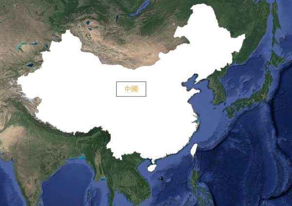
China StudyMap All

China StudyMap PureWhite

China StudyMap+Province EN Blank

China StudyMap+Province EN Marine

China StudyMap+Province EN All

China StudyMap+Province EN PureWhite

China StudyMap+Province ZH Marine

China StudyMap+Province ZH All

China StudyMap+Province ZH PureWhite

China StudyMap+Province Pinyin Marine

China StudyMap+Province Pinyin All

China StudyMap+Province Pinyin PureWhite

China 3DMapAzimuthE+0

China 3DMapAzimuthE+90

China 3DMapAzimuthE+270a

China 3DMapAzimuthE+270b

China 3DMapAzimuthE+270c

China 3DMapAzimuthE+315a

China 3DMapAzimuthE+315b

China StudyMap+River Pinyin Blank

China StudyMap+River Pinyin Marine

China StudyMap+River Pinyin All

China StudyMap+River Pinyin PureWhite

China StudyMap+River ZH Marine

China StudyMap+River ZH All

China StudyMap+River ZH PureWhite


【China K-12 Free Blank Map Name】


JP-Name:中国
ZH-Name:中國 / 中華民國 / 中华人民共和国 / 台湾
EN-Name:Zhongguo / China / Taiwan
ISO3CHN / TWN

JP-Voice

ZH-Voice

EN-Voice


プロ家庭教師の社会地理教材で、指導歴10年以上の講師が執筆しています。


【科目】


社会地理 (公立中学校カリキュラム+高校受験カリキュラム)


【領域】


世界の国地域


【対象生徒】


高校受験生(中学1年+中学2年+中学3年)
高校生(高校1年+高校2年+高校3年)


スポンサーさん

Free Blank Map China Execises


【Free Blank Map China Execises】


【China Nature】


China is a country stretching to the east of the Eurasian continent. China was the cradle of the Yellow River Civilisation before 4000 BCE.

The rivers in China are the Yellow River in the north and the Yangtze River(扬子江) in the south.

China's climate is cold in the north, farming wheat, and warm in the south, farming rice.

The climate of China is different from north to south. There is a traditional four-character proverb, "South Boat North Horse(南船北马)."


【China State System】


China's population is about 1.4 billion. China and India are the only countries with a population of more than one billion.

China's government is composed of provinces(省) and municipalities under direct control(直辖市). The municipalities are Beijing(北京市), Tianjin(天津市), Shanghai(上海市), and Chongqing(重庆市).

China's citizens are assigned rural or urban citizenship(Hukou 户口). Each citizenship has different rights and obligations. Rural citizens migrating to the urban cities for a better job opportunity are called Peasant Worker(农民工).

China's economy is based on communism, which prohibits private ownership of property.

China's official currency is Renminbi(人民元), but it is also referred to as Kuai(块) on the street.

Since the 1980s, China has been experiencing continuous economic growth due to Deng Xiaoping(邓小平)'s Reform and Opening-up policy.

The coastal area has several Special Economic Zones(经济特区). Shenzhen(深圳), Hong Kong(香港), and Hainan Island(海南岛) are the most famous.


【China International】


One Belt One Road(一带一路), also known as the Modern Silk Road, is an economic zone transversing the Eurasia Continent.

Due to the influence of Chinese Hanzi culture, Japan, Korea, and Vietnam together make up the Hanzi Cultural Sphere(汉字文化圈).


【China Society】


China's ethnic groups are mainly Han Chinese(汉族), with over 50 ethnic minorities also having their own autonomous regions(自治区).

Chinese is the official language of China.

Chinese cuisine is famous for its Gyoza(餃子) and Ramen(拉麺), which are made from wheat.

In order to prevent population growth, the One-Child policy(一孩政策) had been adopted but was abolished in 2014.


Free Blank Map China River


【Free Blank Map China River】


【Huáng Hé 黄河】


The name of Huang He(黄河) originates from the color of the loess inland.

Huang He is translated into the Yellow River in English.

Huang He is sometimes referred to simply as "He(河)."

During the Warring States Period, the upper reaches of Huang He were the territory of Qin(秦) State. The many States competed for the management of water resources.


【Cháng Jiāng 长江】


The name of the Chang Jiang originates from its length. The Chang Jiang is the third-longest river in the world and the first in Asia.

The Chang Jiang is sometimes referred to simply as "Jiang(江)."

The Chang Jiang basin has a warm and humid climate, with annual precipitation exceeding 1,000mm.

In the upper reaches of the Chang Jiang, there are Chengdu(成都) and Chongqing(重慶), which are "mountain port towns" and trade centers.

In the middle reaches, Three Gorges Dam(三峡大坝) is the world's largest hydroelectric power plant. Rice cultivation has traditionally flourished. Because of its high yield, a proverb has it: "If Hunan has a good harvest, We are able to feed all the heavens(湖南熟天下足)."

In the lower reaches, Shanghai(上海), the direct-controlled municipality, is located at the mouth of Chang Jiang to the East China Sea.

The Yangtze is another name of Chang Jiang. Yangtze(揚子江) is a famous dialect used by the people of the Yangzhou city(揚州市).

The idea of the Grand Canal(大运河) connecting Chang Jiang and Huang He from south to north was first conceived during the Sui(隋) Dynasty in the 6th century.


Free Blank Map China 3D


【Free Blank Map China 3D】


China 3DMapAzimuthE+0

China 3DMapAzimuthE+0


China 3DMapAzimuthE+90

China 3DMapAzimuthE+90


China 3DMapAzimuthE+270a

China 3DMapAzimuthE+270a


China 3DMapAzimuthE+270b

China 3DMapAzimuthE+270b


China 3DMapAzimuthE+270c

China 3DMapAzimuthE+270c


China 3DMapAzimuthE+315a

China 3DMapAzimuthE+315a


China 3DMapAzimuthE+315b

China 3DMapAzimuthE+315b


Free Blank Map China Terminology


【Free Blank Map China Terminology】


簡体:一孩政策
繁体:一孩政策
拼音:yì hái zhèng cè
日文:一人子政策 / 一人っ子政策く
かな:ひとりっこせいさく
英文:One-child policy
品詞:名詞
-Voice:


意味:一孩政策とは、中国の産児制限のことで、日本語で「ひとりっこ政策」と翻訳されています。


簡体:一带一路
繁体:一帶一路
拼音:yī dài yī lù
日文:一帯一路
かな:いったいちろ
英文:One Belt One Road / Belt and Road Initiative
品詞:名詞 / 名词
-Voice:


意味:一带一路とは、中国の経済政策の1つで、ユーラシア大陸の東西を、陸(=一帯)と海(一路)で結びつける経済政策です。2013年に提唱されました。


スポンサーさん